Landscapes once shaped by machines and human hands are given back to nature and are gradually changing back into lush forests, forming trails of varying exciting climbs and ascents, so hikers, put your best foot forward and explore these wonderful hiking trails – all within a 45 to an hour drive from the city centre!
Level of Difficulty: Easy – Moderate
Activities: Hiking, photography
How to get there: From Kota Kinabalu city, it’s approximately a 45-minutes drive to Bukit Tirig. SK Lapasan is your landmark, and the archway to Kampung Lapasan is just across the road. Drive straight ahead until you see St. Flora’s Church on your right, and park your car at the designated area (there are signages along the way leading up to the starting trail, you won’t miss it). If you’re game for a rougher trail through the village plantation trail, take the route on your left instead of the actual route on your right
The difficulty of the Bukit Tirig should not be understated despite the low elevation, in fact, it’s very unlikely that you’ll find yourself walking on flat terrain along the trail but the rewards, of course, are plentiful. There are two four other trails from the summit that cover much shorter distances but are no less stunning but um, to get there you’ll need to walk through tall grassy trails.
There are two starting trails to summit Bukit Tirig; via St. Flora’s Church (easy) or through the village plantation trail (moderate). The ever-changing landscape will not disappoint; from hiking through the fruit orchard, then through a wild stretch of bushes and jungle creepers, whilst occasionally getting spooked every time the freaky dangly touches your skin. No kidding!
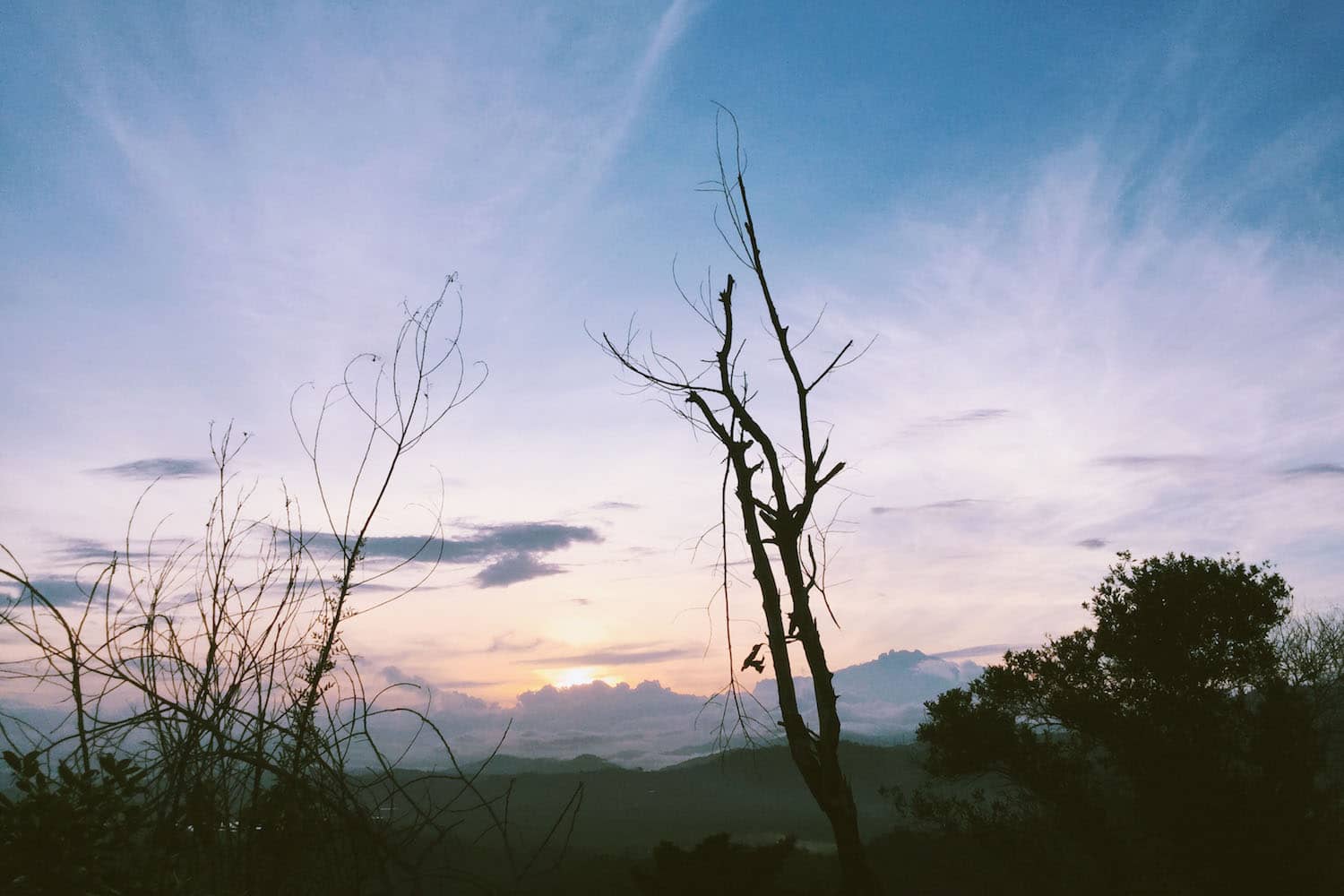
As such, the trails on Bukit Tirig are ideal for day hikes, be it to catch the sunrise or chasing the sunset. Hike your way up at least an hour before sunrise to cop a good spot on the middle summit, or if you’re not much of a morning person, chase the sunset instead. Bring along a picnic basket and hang around till night time for a spectacular view of the sky.
With new paths being added every few weeks by fellow hikers, there’s definitely plenty more to explore beyond the three summits up on Bukit Tirig.
Level of Difficulty: Easy
Altitude: 1164 m / 3819 ft
Activities: Hiking, photography
How to get there: It’s only a couple of hundred metres from Bukit Tirig – drive past INTAN Sabah and you’ll see a signage directing you to the Nuluh Lapai junction. If the Bukit Tirig hike doesn’t tire you out, why not do both in the same morning?
Nuluh Lapai trail is perfect for beginner to experienced hikers and the route is well maintained, well marked, and well travelled – thanks to the villagers! The trail serves as an alternate route for similar views of Mengkabong River and Mount Kinabalu you’ll get from the summit of Bukit Tirig. The trail is perfect for a leisurely hike – perfect of a much needed “get-go” straight off the couch. Logistical planning for Bukit Tirig and Nuluh Lapai are fairly easy, which explains why many have dubbed the hills as their quintessential sunrise hikes before heading back home for shower and breakfast and later on, to work.

Level of Difficulty: Strenuous, but totally doable
Altitude: 117 m / 384 ft
Activities: Hiking, photography
How to get there: Drive to Tamparuli Town and soon as you’ve crossed the legendary bridge, take a right and drive straight ahead until you see St. Veronica Hill on your left (that’s the starting point!) and a multi-purpose hall on your right.
Bukit Perahu, or Bukit Ruhiang as the locals fondly call it, is steeped in romantic and colorful local legends. One in particular is the story of a handsome, obedient young man, Gunsoloi, who whilst building his family a ship on the hill to prepare for an impending flood, fell in love and married an elf princess. Upon visiting his mother after not being home for so long,
With plenty of ups and downs along the sandy and sometimes loose trail, as well as a series of rocky climbs and descents, the hike certainly won’t be easy – in fact, many consider Bukit Perahu, or Bukit Ruhiang, to be one of the slightly more difficult hiking spots in the area and worse, there’s really not much to marvel at on your way up, which could be a bit demotivating. Hit the trail as early as 5 a.m. so you can take plenty of breaks as the climb can be pretty strenuous and you’ll make it in good time for sunrise or sunset on the summit.
Grueling as it is for a casual hike – some sections are pretty easy and the rest are kinda tricky and physically demanding – it’s also one of the most stunningly rewarding summits in the area; some days enveloped in fog and mist, but Aki Nabalu always seems like it’s within reach, and the cool, gentle wind makes everything so dreamy and unreal (despite the fact that you’re on the summit with probably 50 other very loud hikers lol).
Another thing to look forward to post-hike is a big bowl of tomyam soup, mee tuaran and a cold brew at Kentin Bakut, a short 11-minute drive east towards Jalan Tuaran Kota Belud, which is truly a treat.

Level of Difficulty: Moderate
Activities: Hiking, trail running, photography
How to get there: Bukit Tanjung Aru is located between two roundabouts after the Kepayan Ridge – Pintas Road highway tunnel, in the direction of Golden Hill Garden and Shan Tao Secondary School. There’s no available parking space but everyone’s pretty cool about parking their vehicles by the roadside.
Although known to many fellow hikers as Bukit Kopungit, the locals call this hill by two names, Bukit Tanjung Aru (Tanjung Aru Ridge) or Nuluh Kuminaus, which literally translates to “sulky hill” in English.
Over the course of the 2 km loop you can expect to see bird’s eye view of the former Kota Kinabalu International Airport Terminal 2 (KKIA2), Tanjung Aru flyover, Kepayan town, breathtaking sunset view and an air raid shelter tunnel, or bunker tunnel built by the Japanese army – which we think will further solidify your appreciation of Borneo’s fascinating history. As KKIA2 was formerly the home base for Imperial Japanese Army Air Service, according to Azlan Mohamad Jaffar, Head of Research at Sabah Historical Research & Preservation Group, there are probably hundreds or even thousands of tunnels built around Kota Kinabalu for this very purpose!
Bukit Tanjung Aru is not a technically demanding hike, but there are lots of big climbs and descents along the 2 km trail and although this trail sees its fair share of hikers due to its proximity to the city centre, the air raid shelter definitely makes it one of the most iconic trails in Kota Kinabalu.

Level of Difficulty: Moderate
Activities: Hiking, barbecue picnic
How to get there: The Inobong Visitor & Research Sub Station (Penampang) is just about an hour drive from the city centre, and approximately 30-minutes from the Dongongon township via the old Papar road. It’s a steep incline on mostly gravel road until the entrance, but there are waterfalls along the trails so…
Here, nature is allowed to develop freely and the trails wind through lush lowland dipterocarp forest on steep slopes leading to Mahua Waterfall, Salt Trail and Kibambangan waterfall, as well as a multi day hike across the Crocker Range to Tambunan. The vantage points overlook all of the islands and a panoramic view of Kota Kinabalu city. I’ve not been to Inobong sub station (despite the fact that I live so near!) but I will real soon because duh, there’s a waterfall.
Visitor facilities (dormitories, chalets, camping ground, etc.) are available too, so that’s definitely a huge plus!
Level of Difficulty: Easy
Altitude: 117 m / 384 ft
Activities: Hiking, trail running, barbecue, picnic
How to get there: Drive right up to the starting point at True Jesus Church Rongolis, Kampung Rongolis in Topokon, Tuaran.
With an average elevation of 117 metres of well marked and maintained trail through fern bushes, and a flat ground summit perfect for stargazing and picnics, you’ll ease into the hike in no time. Though Bukit Kapur also offers a spectacular view of Mount Kinabalu, if you’re itching for a higher elevation, drive up to Bukit Perahu in Tamparuli instead.
Bukit Kapur is ideal for outdoor enthusiasts of all kinds whether you’re interested in a short morning hike before heading to work, or even a picnic with family and friends. The trail continues to get easier despite the subtle incline, which is kind of contradictory but trust us on this – all in all, it’s great for beginner hikers too.

Level of Difficulty: Easy
Activities: Hikig, barbecue picnic, snorkelling and other watersports
How to get there: Take a speedboat to Sapi Island from Jesselton Point for a day excursion or camp for 2D1N (permit fee applies)
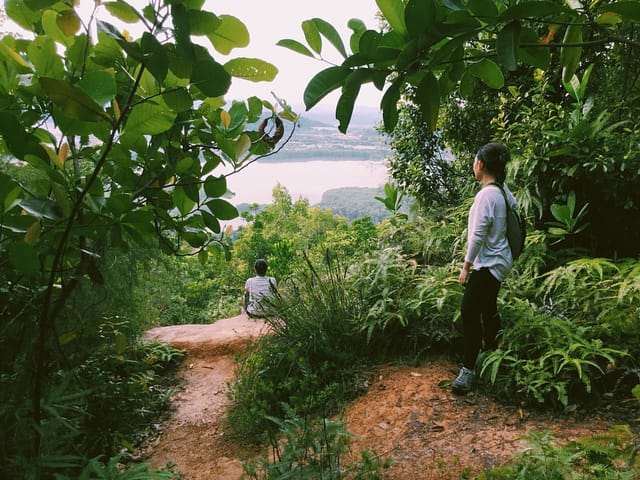
Picturesque weekend hikes or fun daytrips are great to reboot your system and getting rid of weekly stress. If a bad day’s ever got you down, a leisurely hike and a bit of alone time combo can lift up your spirit in a matter of minutes!
Sapi Island is a picturesque and easily accessible island, making it a popular choice for both daytrippers and campers. The water activities can you trip you up but there are a couple of decent ‘tie your hammocks and chill’ opportunities along the hidden hiking trails on the island and if you’re game for the 800m hike to the viewpoint, you’ll be rewarded with a magnificent view of clear blue waters and beyond! It’s an easy hike with subtle inclines and descents, nothing too strenuous so why the heck not, right?
The starting trail, admittedly, is a bit obscure – it’s located at the far end of island (to your left if you’re walking from the island entrance). On your first couple of minute hiking, keep to your right until you see a shrine, then continue on straight to a Y-junction; the one on your left will take you to the viewpoint and the other is looping trail to other side of the island – which is combo of easy descents and beach-walking (if you’ve ever dreamed of owning a private island, you know you gotta explore this trail).
Also, if you’re spending the night on the island, explore beyond the swimming area – the sunset view atop the huge boulders are out of this world!

Level of Difficulty: Easy to moderate
Activities: Hiking, mountain biking
How to get there: Drive up to the iconic Tamparuli Bridge and make a left turn at the junction towards Kampung Bantayan and continue on until you see Sekolah Rendah Bantayan. Park your car, take your water bottle with you, cos this is where one of the trails starts!
Bukit Kusai offers a great mountain bike and hiking experience for all fitness levels and MTB abilities. The pro bikers have used the hill’s network of trails to take MTB enthusiasts through seemingly infinite rows of trees, uphill and downhill, as well as some more challenging and features and steeper dirt jumps for beginner and intermediate riders.
But if you’re not an MTB enthusiast, you should still hike here for the very rewarding Mount Kinabalu view. With good footing and good weather, the trail is pretty easy with a few muddy sections following a heavy rainfall, where you will then have to traipse through with arm flailing in the air for balance.

Activities: Hiking, mountain biking
How to get there: It’s a long drive to Bukit Tompinangan, but everyone seems to have come to an agreement that it’s worth waking up early for… in fact, even all the wrong turns on your way here! Navigate your way to the Tuaran-Tamparuli roundabout, heading towards Kota Belud. Take the junction to Topokon on your right, until you drive past the signboard for Lembaga Industri Getah Sabah. You’ll soon see a tire signboard for Bukit Tompinangan on your left.
The trail is a steady uphill and downhill (and repeat!) with little to no bushes to brave through or trees to hold on too once your legs start to get shaky, so it is advisable to bring a walking stick.
It’s a casual hike to the peak, with no challenging scrambling up and over large rock outcrops as you would experience at Bukit Perahu, and the villagers have made great effort maintaining the trail. So you won’t be trampling on wild vegetation, which makes it the perfect training ground for trail runners to improve their Personal Best (PB).

Level of Difficulty: Easy to moderate
Altitude: 477 m / 145 ft
Activities: Hiking, trail running, community Tai Chi, picnic
How to get there: It’s an easy peasy 20-minutes drive up to Tun Fuad Stephens Park, Bukit Padang from the city centre, driving directions are super accurate on Waze or Google Maps.
Right, so we’re ending our non-exhaustive hiking listicle with the closest trail; approximately a 20-minutes drive from the city centre with pretty rad sunset view overlooking the city and beyond on a clear sky, a cluster of islands and the totally optional ice cendol and kuay teow goreng to fill your belly up, or even a foot massage afterwards as reward… man, there’s no reason not to hike the five trails at Bukit Padang!
The trails vary from what seems like an infinite flight of stairs to the summit (perfect training ground for those of you planning to climb Mount Kinabalu), a paved looping jogging trail, and lots of little loose marked and unmarked trails throughout with subtle inclines which is great for a leisurely or morning or late noon hikes. Depending on the time and day, you can usually meet a fun mix of trail runners, joggers and walkers of varying speed and ability but one thing’s for sure, they are always game for a friendly, chatty competition.
There’s also an alternate route that goes to an unmarked area on the eastside of the trail leading to the summit if you’re keen to chill and have a sunset picnic atop stone boulders – climbing skills required. While it is not advisable to hike at night, the jogging track is lighted up but keep your wits about you to stay safe.